11 June, 2010

Hakaluki haor

Hakaluki Haor is a marsh wetland ecological system of Eastern Bangladesh in an area bordering Assam, India[1]. It is one of Bangladesh's largest and one of Asia's larger marsh wetland resources. Some 190,000 people live in the surrounding Hakaluki haor area[2].
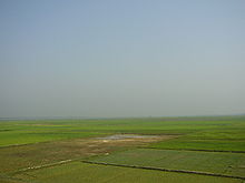
Hakaluki Haor was designated an Ecologically Critical Area (ECA) by the Director General of the Department of Environment, as the ecosystem is considered to have reached a critical state. It also is a protected Ramsar site[3] of international importance for the conservation and sustainable utilization of wetlands.
The surface area of Hakaluki Haor is 181.15km2, of which 72.46km2 (40.01%) is within the territory of Barlekha Upazila. The haor is partly under the jurisdiction of Barlekha Upazila.
Hakaluki Hawor Sylhet Bangladesh 46.JPG
hakaluki haor

No comments:

Post a Comment

Poverty:

It is estimated that more than 40 percent of the population regularly consume less than the absolute critical minimum of 1800 kilocalories per day. These 50 million people are amongst the poorest in the world by any standard of development. Furthermore, it has been estimated that the number of absolute poor has risen significantly. The poverty of these deprived people is deep rooted, pervasive and multi-faceted, relating not just to the absence of reliable incomes and productive assets, but also to food, safe water, sanitation, education, shelter, inequities, injustice and lack of power. These deprived people are also extremely vulnerable to disaster and disease. The challenges posed by this massive poverty are enormous for a country with accelerating environmental degradation of an overpopulated land base. The human development indicators for Bangladesh are also staggeringly low. Bangladesh has an adult literacy rate of 37 percent, life expectancy of 58 years and population below poverty level of 45 percent. Urban slum dwellers now account for some 15 percent of the population and this is still growing by 6 percent per year.